Property Record
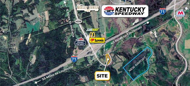
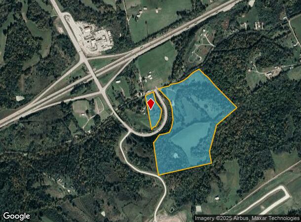
1341 Ky Highway 465 W, Sanders, KY 41083
This Property Is For Sale
NEARBY LISTINGS FOR SALE OR LEASE
Property Detail
1341 Ky Highway 465 W
Cincinnati, OH-KY-IN
Gallatin
011-28
Kentucky
Sfr
80.22 AC
X
Gallatin County
21041C0105E
Cincinnati/Dayton
1,650 SF
DEMOGRAPHICS near 1341 Ky Highway 465 W
1 Mile
3 Mile
5 Mile
2024 Total Population
79
1,065
2,877
2029 Population
80
1,074
2,890
Pop Growth 2024-2029
+ 1.27%
+ 0.85%
+ 0.45%
Average Age
40
41
40
2024 Total Households
29
401
1,081
HH Growth 2024-2029
+ 3.45%
+ 1.00%
+ 0.46%
Median Household Inc
$63,750
$56,735
$56,132
Avg Household Size
2.60
2.60
2.60
2024 Avg HH Vehicles
2.00
2.00
2.00
Median Home Value
$154,545
$148,581
$144,352
Median Year Built
1994
1994
1993
Nearby Places
- Restaurants
- Banks
- Shops
- Fitness
- Groceries
PUBLIC TRANSPORTATION
AIRPORT
Cincinnati/Northern Kentucky International
DRIVE
WALK
Distance
Cincinnati/Northern Kentucky International
48 min
35.4 mi
Freight Ports
Port of Toledo
DRIVE
WALK
Distance
Port of Toledo
290 min
247.4 mi
Nearby Properties
Address
Land Use
TOTAL SIZE
Lot Size
Zoning
Address
Land Use
TOTAL SIZE
Lot Size
Zoning
18.48 AC
COMMERCIAL
Address
Land Use
TOTAL SIZE
Lot Size
Zoning
4.44 AC
COMMERCIAL
Address
Land Use
TOTAL SIZE
Lot Size
Zoning
27.02 AC
COMMERCIAL
Address
Land Use
TOTAL SIZE
Lot Size
Zoning
2.07 AC
COMMERCIAL
Address
Land Use
TOTAL SIZE
Lot Size
Zoning
210.01 AC
Address
Land Use
TOTAL SIZE
Lot Size
Zoning
151.63 AC
Address
Land Use
TOTAL SIZE
Lot Size
Zoning
10,211 SF
2.86 AC
Address
Land Use
TOTAL SIZE
Lot Size
Zoning
600 SF
3.75 AC
COMMERCIAL
Address
Land Use
TOTAL SIZE
Lot Size
Zoning
5.60 AC
Address
Land Use
TOTAL SIZE
Lot Size
Zoning
55.72 AC
Address
Land Use
TOTAL SIZE
Lot Size
Zoning
2.37 AC
Address
Land Use
TOTAL SIZE
Lot Size
Zoning
1.56 AC
Address
Land Use
TOTAL SIZE
Lot Size
Zoning
4,010 SF
532 AC
Address
Land Use
TOTAL SIZE
Lot Size
Zoning
2.49 AC
COMMERCIAL
Address
Land Use
TOTAL SIZE
Lot Size
Zoning
38.04 AC
RESIDENTIA
Address
Land Use
TOTAL SIZE
Lot Size
Zoning
14.10 AC
COMMERCIAL
Address
Land Use
TOTAL SIZE
Lot Size
Zoning
1.24 AC
Address
Land Use
TOTAL SIZE
Lot Size
Zoning
1,400 SF
0.91 AC
COMMERCIAL
Address
Land Use
TOTAL SIZE
Lot Size
Zoning
1,500 SF
1.88 AC
Address
Land Use
TOTAL SIZE
Lot Size
Zoning
0.80 AC
Address
Land Use
TOTAL SIZE
Lot Size
Zoning
4,000 SF
8.71 AC
Address
Land Use
TOTAL SIZE
Lot Size
Zoning
63.17 AC
Address
Land Use
TOTAL SIZE
Lot Size
Zoning
1,008 SF
28 AC
Address
Land Use
TOTAL SIZE
Lot Size
Zoning
Address
Land Use
TOTAL SIZE
Lot Size
Zoning
4.13 AC
RESIDENTIA
Address
Land Use
TOTAL SIZE
Lot Size
Zoning
Address
Land Use
TOTAL SIZE
Lot Size
Zoning
75.48 AC
COMMERCIAL
Address
Land Use
TOTAL SIZE
Lot Size
Zoning
1,924 SF
5.01 AC
COMMERCIAL
The World's #1 Commercial Real Estate Marketplace
Connect with us
© 2025 CoStar Group
The information above has been obtained from sources believed reliable. While we do not doubt its accuracy we have not verified it and make no guarantee, warranty or representation about it. It is your responsibility to independently confirm its accuracy and completeness. Any projections, opinions, assumptions, or estimates used are for example only and do not represent the current or future performance of the property. The value of this transaction to you depends on tax and other factors which should be evaluated by your tax, financial, and legal advisors. You and your advisors should conduct a careful, independent investigation of the property to determine to your satisfaction the suitability of the property for your needs.